Converting 3D polygons to 3D loci
|
Command |
Workspace: Path |
|
3D Polygons to 3D Loci |
Architect: AEC > Survey Input Landmark: Landmark > Survey Input |
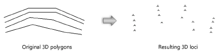
The 3D Polygons to 3D Loci command converts the vertices of selected 3D polygons into 3D loci. These loci can then be used to create the site model.
To create 3D loci from selected 3D polygons:
Select the 3D polygons to convert from the current layer.
Select the command.
The 3D Polygons to 3D Loci Command dialog box opens.
To remove the 3D polygons, select Delete original 3D polygons.
The vertices of the selected 3D polygons located in the current layer are converted to 3D loci. The loci retain the Z values of the original polygons. These 3D loci can then serve as source data for the site model, or can be converted to stake objects and modify an existing site model.